:::::: ³ª¶ó[µ¶µµ]»ì¸®±â¿îµ¿º»ºÎ ::::::
ÀÛ¼ºÀÏ : 20-09-13 15:10
 ±Û¾´ÀÌ : ¼÷¸í¿©°íÈ«¼­Á¤
Á¶È¸ : 745  
https://theolympians.co/tag/syngman-rhee-line/
¼­ÇÑ ½ÃÁ¤¼­ÇÑ 
¸Åü À¥»çÀÌÆ® 
À̽´  
¾ð¾î ¿µ¾î
¼­ÇѺ¸³»´Â°÷ https://theolympians.co/tag/syngman-rhee-line/
¿À·ù³»¿ë µ¶µµ¸¦ takeshima¶ó Ç¥±â
E-mail / Contact sjhong0603@gmail.com
¼­·Ð


Dear webmaster, 


Hi. This is Seojeong Hong who studies oceanography in South Korea.

I was googling for some information about Korea for my project, and I found your website.


º»·Ð

While I was using your website, i found a mistake in the picture you use in your website.

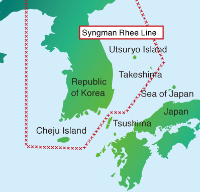
The island between Korea and Japan was written 'Takeshima'.


Actually, the island should be written 'Dokdo'.

The island is in Korea's territory.

The distance between Korea and Dokdo is more smaller than that between Japan and Dokdo.


Also, there are many historic sources that show Korea consists Dokdo.

Since Chosun period, our ancestor had recognized the island our territory because they can see the island in their naked-eye when the weather is good.

Even the Korea map made on Chosun period includes Dokdo.

Japan has recognized it in 1900, the period before 1905 when Japan had colonized Chosun.


You can find a lot of information in [https://dokdo.mofa.go.kr/eng/] for Korea's position on Dokdo.


°á·Ð

I would like you to correct the name 'Takeshima' to 'Dokdo'.

Thank you for your interest in this topic and your help, and if you don't mind, could you let me know an E-mail address.

I look forward to hearing some good news.


Sincerely,
Seojung Hong


¼­ÇѼö½Åó  [º¹»çÇϱâ]
Á¦¸ñ  [º¹»çÇϱâ]
Ä£¼±¼­Çѳ»¿ë  [º¹»çÇϱâ]